By Emma Barhydt
Greenwich entered the second half of January without obvious signs of trouble. The day was cold but unremarkable. Roads were clear. The harbor was calm. For most residents, winter remained background noise.
According to meteorologist Ryan Hall, however, the broader atmospheric setup now in place suggests that this winter—and the days immediately ahead — may not remain subdued.
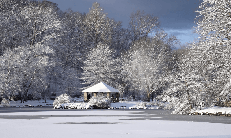
Greenwich is forecast to experience a major winter storm beginning before dawn Sunday, January 25, with snow continuing through the day and into early Monday. Temperatures are expected to hold near 18 degrees, cold enough to support steady accumulation with little to no melting. Northeast winds near 15 miles per hour, with gusts approaching 30 miles per hour, are expected to reduce visibility and contribute to drifting snow.
Snowfall totals in Greenwich are currently projected to range from 6 to 17 inches, reflecting uncertainty in snowfall intensity and duration while indicating the potential for a high-impact event. Roads and sidewalks are expected to become snow-covered quickly once precipitation begins, particularly as temperatures remain well below freezing throughout the storm.
The heaviest snowfall is expected during the late morning and afternoon hours Sunday, with lighter snow continuing into early Monday. With cold air remaining firmly in place, untreated roads and sidewalks are likely to remain snow-packed and slippery through the end of the weekend and into the start of the workweek.
Wind will be an additional factor. Despite air temperatures near 18 degrees, sustained winds are expected to push wind chills toward zero Sunday night, increasing the difficulty of prolonged outdoor activity and slowing cleanup efforts.
Cold conditions are expected to persist after snowfall ends, limiting melting and extending the presence of snow and ice across much of Fairfield County. In similar past events, such conditions have prolonged travel disruptions and required extended snow removal operations.
Hall, who has been tracking both short-range forecasts and long-range climate signals, explains that the current season as one shaped less by a single dominant driver than by the interaction of several weaker ones. Together, he says, those forces are producing an elevated risk of high-impact weather events across the Northeast including Fairfield County.
At the center of that pattern, Hall explains, is a weak La Niña in the Pacific Ocean. Sea surface temperatures are only marginally below normal, just enough to meet the technical threshold typically used to define La Niña conditions. On its own, Hall notes, such a weak signal would usually have limited influence on winter weather in the eastern United States.
This year, however, the La Niña is being reinforced by a strongly negative phase of the Pacific Decadal Oscillation, a longer-term ocean pattern that affects the entire North Pacific basin. When the two patterns align— even imperfectly—they tend to push the jet stream farther north than average, according to Hall. That shift favors colder air across northern states while allowing warmer conditions to persist farther south.
The result is not a clean divide but a broad transition zone where cold and warm air repeatedly meet. That zone, Hall says, becomes a frequent area of storm development.
Greenwich sits close to that boundary.
Hall characterizes southern New England as a transition region—an area that recently has had cold air but not snow. The pattern this year is different.
To understand how this pattern typically behaves, Hall analyzed seven analog winters dating back to 1989 that featured similar combinations of a weak La Niña, a negative Pacific Decadal Oscillation, and warm Atlantic waters. Among them were the winters of 2013–2014, 1995–1996, 2017–2018, and 1989–1990.
When those winters are compared, Hall says, a consistent signal emerges. Northern regions averaged well above normal snowfall, while southern regions saw substantially less. More important than totals, however, was what each of those winters shared: at least one significant winter storm or Arctic cold outbreak that left a lasting impression.
“That’s not coincidence,” Hall has said. “That’s a pattern.”
One factor increasing the likelihood of such events this season, according to Hall, is the state of the polar vortex. The polar vortex is a large circulation of Arctic air high in the atmosphere that, when stable, keeps the cold confined to high latitudes. When disrupted, Arctic air can spill southward into the United States, sometimes persisting for days or weeks.
Hall notes that the current atmospheric configuration historically corresponds to a 60 to 75 percent chance of polar vortex disruptions. He cautions, however, that such disruptions do not always result in snow. In some cases, Arctic air arrives dry, producing severe cold without significant precipitation.
That uncertainty is part of what has kept forecasters focused on the days immediately ahead, bringing us back to our current forecast.
Expect to be hunkered down beginning before dawn Sunday, with snow continuing through the day and into early Monday.
For Greenwich, the forecast reflects the broader theme Hall has emphasized throughout the season: a winter defined less by constant storms than by periodic moments of consequence. Outcomes, he notes, often become clear only shortly before an event begins, as small shifts in temperature or storm structure can produce outsized effects in southern New England.
For now, Greenwich remains in its familiar January rhythm. But according to Hall’s analysis, the larger atmospheric pattern suggests that winter’s more consequential moments are still ahead—with conditions that leave little room for error so be careful and plan accordingly.