From the Office of the First Selectman regarding the forecast for Sunday into Monday.
Greenwich residents urged to prepare for potentially stronger impact from storm
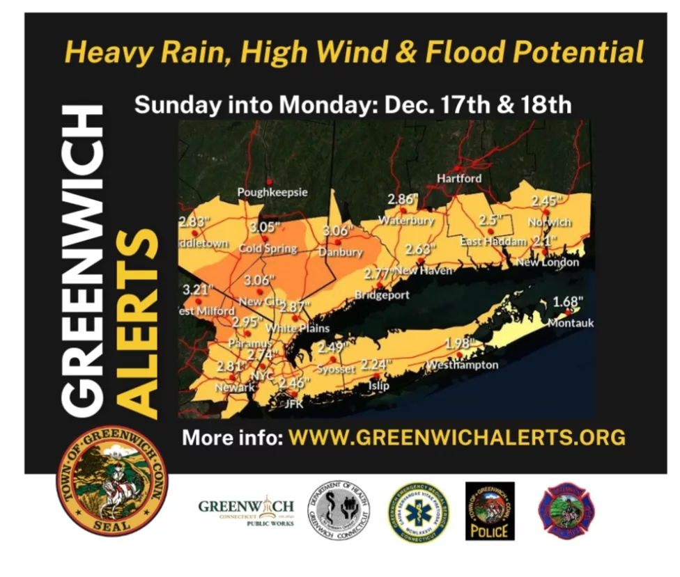
The storm expected to hit Greenwich and the surrounding area starting Sunday night is forecast to be more powerful than the one last week and Greenwich residents should be prepared.
According to the National Weather Service, a coastal flood warning and a high wind warning will be in effect from Sunday night into Monday.
According to the latest forecast, moderate rain will spread into Connecticut from the south around 6 p.m. along with winds at 25 mph that could potentially gust to 40 mph along the coast by midnight. There are not expected to be major impacts on travel before midnight but residents should be prepared for potentially scattered power outages.
The forecast becomes more severe during the overnight hours.
Overnight there is expected to be moderate to occasionally heavy rain with southeast winds increasing. Gusts may reach as high as 55 to 65 mph in valley locations across the State of Connecticut. Power outages are possible due to potential tree damage from the wet, unfrozen soil.
There is the potential for some minor urban flooding along with minor river and stream flooding. Minor coastal flooding is also forecast when high tide hits just after 1 a.m. in eastern Long Island Sound and just after 3 a.m. in western Long Island Sound.
People out at this time must take caution because low lying roads may be flooded.
On Monday morning, moderate to occasionally heavy rain is expected with strong south and southeast winds during morning rush hour. The winds may gust to 55 to 65 mph at the coast. And 40 to 55 mph inland.
Town of Greenwich officials will continue to monitor the weather closely and updates will be brought to the public as needed.
First Selectman Fred Camillo continues to urge residents to be prepared and take precautions against potential flooding and power outages in Town. Also people should take extra care when driving on Monday morning.
Eversource Energy has informed the Town that it has activated its Emergency Response Plan and that it will have additional teams around the State to respond to outages.
 |
Message from ToG Emergency Management Department regarding upcoming storm.
Greenwich Alerts: Flood Warning Issued
Message:
The National Weather Service has issued a Coastal Flood Warning, as well as a High Wind Warning and Flood Watch for the rest of the area starting Sunday evening, December 17th through Monday evening, December 18th.

The local forecast calls for rain starting Sunday night and continuing through Monday afternoon. There is a possibility of widespread rain totaling from two to four inches of rain, with possible localized amounts in the excess of five inches. In addition, wind gusts of approximately 50 miles per hour that may cause limbs and trees to fall creating power outages. Eversource has activated their emergency operations plan and will be working with the Greenwich Emergency Management Team to restore any reported electrical service interruptions quickly, once safe to do so.

This event presents an areawide flood threat to both the coast, low-lying areas prone to flooding, and along streams and riverbanks. The ground is very saturated with water.  The amount of rain that is being forecasted can cause basements and homes to flood. If your basement, or home is prone to flooding, or if you are concerned your home may flood, please consider using today to prepare to help protect your family and belongings.

Please do not drive through flooded areas. Remember to “Turn Around, Don’t Drown.”

In the event of quick rising water, move to higher ground.

The Greenwich Emergency Management Team will be monitoring this event closely and may provide updates or emergency information over the next 24 hours, if necessary.

Please be safe and remember to call 911 in an emergency.

